|
|
|
|
Northern Epic: Newfoundland
and Labrador
photo album
"Now when I say that I am in the habit of going to sea
whenever I begin to grow hazy about the eyes,… I do,
not mean to have inferred that I ever go to sea as a
passenger. For to go as a passenger you must needs have
a purse, and a purse is but a rag unless you have something
in it. Besides, passengers get sea-sick—grow quarrelsome—don't
sleep of nights—do not enjoy themselves much, as a general
thing; --no, I never go as a passenger; nor, though
I am something of a salt, do I ever go to sea as a Commodore,
or a Captain, or a Cook. … It is quite as much as I
can do to take care of myself, without having taking
care of ships, barques, brigs, schooners, and what not….And
as for going as cook,…somehow, I never fancied broiling
fowls… No when I go to sea, I go as a simple sailor,…
True, they rather order me about some, and make me jump
from spar to spar, like a grasshopper in a May meadow.
… What does that indignity amount to, weighed, I mean,
in the scales of the New Testament? … Who ain't a slave?
Tell me that. ….Again, I always go to sea as a sailor,
because they make a point of paying me for my trouble,
whereas they never pay passengers a single penny that
I ever heard of. On the contrary, passengers themselves
must pay. And there is all the difference in the world
in the world between paying and being paid. … Finally,
I always go to sea as a sailor, because of the wholesome
exercise and pure air of the forecastle deck."
from Moby Dick; or, the Whale. Herman Melville.
New York: Harper & Brothers, 1851
read
entire monologue of Ishmael
sort of near the beginning...
Jackson's Arm
Perry keeps applying the emergency brake while driving
down the several hills of the very spread-out village(kinda
like far apart beads on a rosary) because apparently
(it dawns on me) there are no brakes on the mini-van.
He grabs the beer caps and tosses them out the window
and shortly follows with the bottles themselves. Yes,
he agrees, we have a drinking and driving law, too,
but the RCMP hardly come over and I just toss 'em quick
anyways so it's ok. He gives us a tour to the 2 or 3
dead ends of the village. (Jackson's Arm is itself the
End of The Road). It's amazing to someone like me from
the tightly clustered towns of eastern US, how amazingly
spreadout this village is--lots of isolated houses over
several miles. Perry sez that everyone in town is related
by either blood or marriage. The mayor is a buddy(or
cousin, I forget which) of his and he really can't understand
why he didn't answer my letter. And when I did return
to Ohio, sure enough, there was Terry's response. There
always seems to be one small boat or another moving
about the harbour. We go to a local club--their word
for bar--where several former residents and locals have
gathered. We meet some older fisherman and talk a little
about the weather. Doug has 2 or 3 beers and buys a
round, and a bag of chips which we make last 2 days
I think. Then Perry takes us on a tour of the crab and
shrimp processing plants--at least the parts without
any open processed product.
Great Harbour Deep
They are great fans of Be a Millionaire tv show
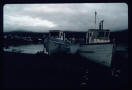
MV Lady Rosella Regina B
The crew let everyone into the wheelhouse that wanted
to. Then they let the baby of a big reunion group have
its picture taken as if steering the wheel
A traveler merely glancing at a map of the province
of NF knows instantly this is no ordinary land they
are heading into. First of all half of NF is a 0000
square mile island at the edge of the North Atlantic.
All settlements are on the highly & raggedly indented
coasts of both the island and its mainland territory
called Labrador. And a closer inspection reveals the
puzzling absence of roads leading to many of these settlements...
Thus it was that my friend and I were riding a watery
route between these villages--for freighters, ferries
and fishing boats are their main connection to the rest
of the world. (Plane, float plane, helicopter and snowmobile
are used to compliment their supply and travel needs.)
Our budget "held us back" to the slow scenic route (to
our delight actually!) and we found ourselves riding
ocean swells northward on the well worn, even slightly
greasy, deck of the MV Lady Rosella Regina B, a refitted
RCMP boat ?that once used to sweep for mines? As the
scattered houses around Jackson's Arm harbour faded
out of sight dark rocky cliffs rose on our left and
on our right--well, nothing separated us from England
and Ireland, the homelands of the ancestors of those
living along these rocky shores today. Nothing except
whales which the other passengers--all returning to
visit relatives --helped train our eyes to pick out
by the unfamiliar sprays and churnings of water that
betrayed the tons of whale body swimming below the surface.
Our destination was the village of Great Harbour Deep
where we would stay at the Danny Corcoran Lodge.
The next morning we hired the owner to sail us further
north on his fishing boat longliner to Englee xxxx miles
up the coast with a stop at the abandoned whaling station,
Williamsport. The station is an incredible rusted seabound
ghost town. Captain Pittman imparted a wealth of a history
lessons about it and gave us close-up views of bald
eagle, iceberg, a surfacing humpback whale, and the
wild rocky headlands which I never tired of. When the
Captain went below he handed the wheel to Doug--to his
utter delight he got to steer a real longliner in the
North Atlantic, slowly spinning the large wooden wheel
back and forth until lunch was ready. We never touched
land in Englee, merely tossed our baggage over into
the next longliner that we'd hired, jumped on board
and began steaming eastward to the Grey Islands lying
00 miles out. It was a rougher sea and we occupied ourselves
playing "Find the Loons When They Pop Back Up" and alternating
between the snug warmth of the wheelhouse and the refreshing
salt breeze out on the prow clutching to coils of line
for balance. This trip (which had actually begun five
vessels earlier-but we could only cover one section
in this article) being our first encounter with the
sea we were almost religious about fending off any possible
reintroduction to our lunch by staying in the front
of all boats, out in the fresh, cold air.
We spent 3 magical days exploring the uninhabited island
never getting very far from the tiny cabin because there
was so much geology, so many flowers and birds, seals,
even old marble headstones and building ruins to enjoy.
Delayed by a running of the capelin the skipper returned
a day late and carried us through very rough seas past
a puffin island and wondrous wave-carved sea stacks
to his village of Conche. A wish came true for me: the
famous knarr, the Snorri, was docked as part of the
Viking 2000 Celebration taking place all over the Great
Northern Peninsula area of NF. (The Snorri had sailed
from Greenland to Newfoundland). The next morning we
continued our big adventure by meeting a bus to St.
Anthony, a community further north, where we would catch
a freighter to travel up the Labrador coast to the Inuit
community of Hopedale, something which would take two
weeks. Upon returning to the Island we reluctantly turned
south and homeward, stopping to examine geology and
arctic plants in the Burnt Cape Reserve in xxxxx and
Xxxxxx Reserve in Bellburns, and in Gros Morne National
Park. Three hikes through awesome landscape including
two fiords and exposed mantle rock were the second to
the last things we did. The last thing we did was enjoy
rich moose stew at the Xxxxxx in Wiltondale and meet
more persons that we could add to the endless stream
of friendly Newfoundlanders who were so warm and kind
to us.
Grey Islands
Note: Paul sez there are no moose on the island so what
I saw was a caribou.
July 20, 2000
The same seal came back last night or this morning.
I was watching this light gray rounded rock since daybreak
which looked like a caribou lying on its side in front
of the cabin. Then about 7:30 when Doug went out to
crush our “tin” cans he startled it. It is light gray
area underneath, with dark grey spots, darker grey head
and upper side. It swam all around cove whining and
barking at times. This must be his or her cove. It crawled
up on the rock again, and slept under our slanted lines
of drying clothes. The little duck came back. Beautiful
clear morning. [boat came about 1:30-2:30]
I was sketching the elusive fireweed, green orchid and
the bakeapple and pitcher plants (see previous pages
sketches) near the old recovered cemetery when I heard
and saw a speck like the Bromley boat far in the distance.
Ran back most of the way down the old grassy road to
tell Doug. We had just got back from hiking the hill
behind the cabin where views from the top were wonderful
(see sketch on earlier page). Looks like Disneyland—like
a Magic Kingdom, all the ponds and islands. Found a
caribou antler and a fox jawbone up there. Found more
berry plants of unknown type this time way up on a peak
(i.e. just a hill) that had a cairn. Doug heard a chickadee
there.
Notes: Butterfield Group Tours—Paul brought them over
but they had their own guide
Sea stacks, steep waves, whales, bird isles, iceberg,
crabmeat, cabin
When Paul finally came to fetch us we saw why he was
so late as there were a great many people on his boat.
All except a honeymooning couple, Jackie and Brett,
were with a high class tour company called Butterfield
Tours. From talking to most of them they seemed well-to-do
and were spending over $4,000 each for the tour of Newfoundland.
They were using the Tuckamore Lodge for a while and
Barb Genge had even made the honeymooning couple move
to a different room to accommodate the big group somehow,
and they were feeling neglected by Barb. They had gotten
to go out in Hare Bay in kayaks
July 24
skipped
# Go back down to the wharf and get our tickets from
a stodgy elderly purser. We buy a leg of the journey
at a time. Doug roams the ship checking everything out.
It’s really cold in the shadows around the wharf. We’re
very tired, thirsty and weary. A slew of Operation Sail
sailboats are here and one more comes in. Their masts
are so tall. Doug gets a good shot of a group of seasoned
fishermen with their working boat against the contrasting
cruisers. Northern Ranger is a working freighter. Saw
my first jellyfish (ever) swimming (see sketches) beside
the Northern Ranger at the St. Anthony dock. Two got
their tentacles attached and had quite a struggle to
separate themselves. They’re reddish, burnt sienna colour.
They do a constantly pulsating up and down swim, coming
up to the surface every so often. The more we look the
more jellyfish we see in the water all along the pier.
A couple and their child drive up and with the wife
busy lettering more notices on her lap, the husband
tapes up the notebook sheets that read in red marker:”
Fisherman, Needs Work, call…..” I call Trudy as promised
and she sez her boyfriend, Pascoe (named after Grenfell’s
son) will show us around about 8:30…
Skipped Library description
We sit watching dozens of cars drive aimlessly around
the wharf. Trudy, Pascoe, and her brother Tyson come
to drive us on a quick tour of the countryside. We go
through Great and Little Brehat, Goose Cove, St. Anthony
Bight and Carol’s Cove (check). These villages are very
tiny. We see 2 moose. Tyson points out all the good
trouting ponds. Goose Cove was a little livelier and
looked the most interesting. There were very steep hills
that Pascoe’s little overloaded car could barely make
up. We were warm and sleepy. He seemed to enjoy showing
us around. Tyson had had no luck salmon fishing. They
dropped us back off at the Ranger with the insistence
that we stop again on our way back.
Moved our bags upstairs. The crew is friendly. Followed
the suit of other people setting up camp in the 2 lounges.
We’re very tired. The Ranger is supposed to leave at
3 am. There were no kitchen hours all day and night,
and no hot drink machines. There are 3 decks and an
area out on the bow. There are families, a bunch of
children and one scruffy game little dog named Nickie
who has to stay in one of the pet containers on the
stern. (see sketch) We can smell bread baking and a
grey-haired man who looks like a First Nations remarks
about it. We notice he’s got outdoorsy gear, a nice
red soft pack and I point out an axe handle sticking
out the top. We suppose he going bush camping in Labrador.
He wanders outside to smoke in his stocking feet and
seems to make odd remarks. We stuff our 2 travel saks
behind his area of the lounge and lie down in the other
lounge, half under some of the attached chairs and tables
to keep out of the way of being stumbled over. Loud
voices start to wake me up with some fellows who sound
slurred cursing and arguing about bears, telling bear
stories, “you gotta look at a bear like you’re gonna
have him for breakfast” and “look, now you’ve woke him
up!”, “That’s cuz he’s one who wants to hear the truth.”
This last was directed at Doug who had realized these
guys were in our lounge and got up. Earlier I’d seen
2 ominous rough-looking fellows sprawled over several
chairs, looking belligerent with dark beards and t-shirts
and baseball caps. Later I heard them going to buy tickets.
I never opened my eyes until the shouting and yelling
woke me up a little while later, someone shouting, “Don’t
you ever try to f--- with nobody from Labrador,” over
and over again and I saw one of the rough-looking guys
on top of the grey-haired odd fellow, smacking his arms
up and down and jumping on him shouting with each smack.
A couple people yelled to get the steward and the purser,
and a lady said, “Okay everybody calm down, now”. The
dark-haired guy got up, the crew came, a crowd gathered,
muttering and staring. Apparently the dark-haired guy,
also drunk from drinking whiskey in the “no alcohol
allowed” lounge had come over to bother or challenge
the grey-haired guy and/or fell asleep nearby and claimed
that grey-haired had come after him with his axe. Coincidentally
he’d made sure this all happened before the ship left
port. Grey-haired just lay there till finally they had
him bag up all his scattered belongings. Some short
little young man came over smoking and volunteered that
we shouldn’t worry, this bad fellow was leaving. It
was a pretty frightening scene to wake up to and see
but still was puzzling as to who actually did what.
After an hour or so the RCMP came and took him away.
Then they could start the engines and the Ranger got
underway as it was getting light. The 2 lounges being
in the stern over the motor rattle and shake tremendously,
all the aluminum trim rattles. It’s easy enough to sleep
though. Many people set up camp taking 2 rows of facing
seats. A few nights later we actually sack out where
that incident took place. It haunts my ears for a couple
days. The ship rocks all the time with the swells and
the steering actions.
The cafeteria is open only 4 hours a day and the food
is a little weird. Toast and coffee are the best. And
the little tubs of Cheez Whiz, peanut butter, marmalade,
raspberry and blueberry jams, mayo and barbeque sauce.
Bottles of Tabasco sauce. All the tables have a raised
ridge on the edges to try to keep everything from weather.
Labrador Coast
First day, Tuesday (July 25,
2000)
we round the tip of the Northern Peninsula and cross
Belle Strait and get to Red Bay. There are about 5 small
Viking boats here, crewed by Swedes and Norwegians or
? and one big motorized Viking boat. They are all in
authentic gear. Some have wooden shields and plastic
caps for fun. One boat’s dragon head prow has red reflector
eyes which may even light up (?). More than one boat
has a dragon head. I take photos of a Labrador retriever
dog repeatedly retrieving what looks like a beer bottle
his owner keeps throwing from the shore. I check out
the Basque boat they found recently and the big paintings
of whaling in the 2 museums. I check out a tiny wooden
craft shop with a wood heater and a bigger shop with
an eatery. Doug crawls around on rocks examining their
composition. I cross the marsh to the Red Bay Airport.
It’s bare and open and desolate and there are no trees.
This is the end of the road. There is a lot of cotton
grass. It’s sunny mostly but then a fog rolls in. There
are lush gardens behind wooden white fences. When we
take off the ship has to use its fog horn and it’s foggier
out to sea.
Mary’s Harbour, Port Hope Simpson –we anchor here overnight,
mosquitoes infest the ship, we watch Smilia’s Sense
of Snow—I less than Doug, trying to sleep but mosquitoes
keep me up,[Pinset’s Arm, Charlottetown]
July 26
Next morning at breakfast there is a huge iceberg right
next to the ship—several stories high—and probably equal
or more below the surface. I was able to watch it for
a long time. We were eating breakfast with Betty the
biologist and by the time I get up on deck I do not
get many photos of it. Doug and Betty see it go by in
the portholes by their table. Betty handed me a slip
of paper with the entire common names and Latin names
for a flower we’d discussed earlier.
At Pinset’s Arm it is not deep enough for the Ranger
to get to a dock so all skids of groceries and supplies
are taken ashore in a bout 5 trips with a dory (motorboat)
with 2 fellows. A crane lowers the skids. The Ranger
takes on skids of fish products of different kinds and
we find out little the tour guide knows – disheartening,
but we didn’t pay for her services anyway. One of the
crew pulls out a conche/whelk? out of the cases being
sent out to be processed to show the tourists what it
looks like. Most villages have some type of “fish” plant-can
be crab, shrimp, fish, fish eggs or other. The plants
have huge tanks of fuel. The skids of supplies for Norman
Bay also have to be unloaded this way to a few boats.
One is a skid of crab pots. We see lots more Innu and/or
Innuit and/or Metis people. A lot of them are weathered
older men. At one point a snowmobile is hoisted to the
wharf. There are skids of Frito Lay products for every
village. Often things appear precarious but they know
just what they can get away with. At Norman Bay a larger
family, a little worn at the edges and with their curly
black happy dog and many taped boxes in tow, go ashore
by boat. At one point a box gets dropped by a young
boy and there is the sound of shattering glass. The
variety of and handling of the freight is so real and
fascinating. The Northern Ranger draws a crowd of scrambling
pick-up trucks, ATV’s, people on foot and bicycle, kids,
old folks, relatives. Once some youths set up a table
of pottery for sale. It is a tiny carnival every 12
days. Another time there is a real hot dog stand of
some sort. Fishing boats of different sizes going in
and out.
The 2 dark-haired fellows from earlier turn out to be
off-shore fishermen who work on a boat which returns
to St. Anthony where they take the Ranger to their home
in Black Tickle, where on of them will take a smaller
boat to Goose Bay to get his wife at her job. The other
lives with an aunt and he talks to Doug a while about
30 foot waves and rough seas preventing them from even
drinking a cup of coffee.
At Indian Tickle we finally say goodbye to Nickie, the
scruffy white dog and his big family who get off into
small bobbing boats. It’s very dark and foreboding,
thw water quite choppy and there is no village to be
seen.
At Black Tickle I see a new pink flower—see sketch of
7/16. There are huge flat rounded boulders and no trees.
They are working on adding to the fishplant.
We dock at Cartwright, but before we do we see a huge
wonderful display of Northern lights—they even pulse
and the curtain dances after a while. (see sketch)
There are tons of icebergs, most a distance away, but
sometimes you can see 15 at a time. We sight several
whales – their spouts—and once one is flipping and smacking
its tail. Someone sights puffins.
Someone explains Canadian civics to us in the cafeteria
but it is so baffling and complex we almost immediately
forget. Another mid-older couple, tall, fit and greying,
have a cool aeronautical map and tell me all their Labrador
adventures and an ocean-going canoe. Later I notice
(they’re active readers) they have dropped 2 bookmarks
on the seats and in handing them to them I see the name
Northern Books, George Luste—someone I was thinking
of contacting for NF and LAB books since he was recommended
by Gary Conover. I say this to this couple and he says,
“I am George.”
July 27 Rigolet
August 4, Red Bay return,
Hard time writing all the way to Red Bay, sea choppy.
In Red Bay we pick up souvenirs, write postcartes and
send postcard painting to Garrett Conover (NorthWoods
Ways in Maine) while being eaten alive by blackflies.
We notice a huge rusted hulk of some ship out in the
bay. The craftstore owner used to run a movie theatre
in st. Johns and having picked Labardor to retire in,
is glad to have established his shop before the Park
Service buys the area. Can’t eat lunch we buy, upset
stomach. Everybody busy exchanging addresses.
Finally figure out the words to the song that the First
Officer, George, sings when he dresses up in his costume
and plays his crazy stick and dances the jig for: “I’se
da B’y” (I’m the One[the boy])
The tour group gets private concerts that don’t look
that fun, or different from what George and Derek (&
woman?) do in public.
Betty sights a water pipit in Red Bay.
August 5, Burnt Cape Reserve
Walked to Violet Major’s Hospitality Home and made arrangements
to stay a couple nights. She immediately told us to
not mind the old geezer(what term did she use??)—her
apparently lazy husband(or boyfriend) in a steady state
of inebriation. He was thin & grey-haired and we had
a hard time understanding things he mumbled in our direction.
We heard Violet complaining to him about not doing any
work. We settled in the damp basement room and realized
we couldn’t use the kitchen down the hall—at least not
willingly as it was caked in mold & other life forms.
Our room also was alive after dark with crawling beetle
things & other critters. But we were welcome to use
the upstairs kitchen & living room and Violet was all
in a uproar of cleaning a few rooms for the semi-surprise
visit of some tourist ratings board members arriving
any day now. She immediately had us attempting the impossible
repair job of a broken curtain rod in another room &
making that bed. Went to store, made lunch, and started
hiking to the park office and got picked up a few yards
up the road by Scott McAlpine, the nice photographer/reporter
from The World & I that had rode the Northern Ranger
with us.
On the lift to the office we happened to mention Doug’s
forgetting our nice compass in the Imagliat Inn in Hopedale
and Scott insisted we borrow his! Got in line for our
pre-trip “speaking with the ranger” pre-requisite for
our backpack trip on the North Rim of the Western Brook
Pond. Watched some precautionary videos about the hazards
of coastal mountain hiking with cliffs and impenetrateable
vegetation and unmarked trails.
They seemed to be starring Sue and Bob xxx/Rendell of
Gross Morne Adventure Guides service who in fact had
been quite kind in answering my e-mailed questions about
the trails and shuttles. The video player baffled our
group but finally got through the required footage and
moved up to the ranger debriefing pedestal where he
had us-or rather, Doug, demonstrate hypothetical route-finding
abilities with our newly acquired compass on the topo
maps of the Long Range Mountains. There were some embarrassing
moments with getting used to the new compass but Doug
eventually passed this test for the both of us. I’m
always grateful one of can do the plotting so automatically.
The ranger explained about the absence of a trail, how
long we were supposed to arrive at certain campsites
at certain times and mentioned bad weather days being
taken into account before the rescue would begin. We
watched and sat with the other larger groups and observed
a variety of route finding skills, and that this was
a lot more popular than we thought. The ranger mentioned
a new park management plan being in the works out of
fear of overuse. The park is fairly new and wants to
cut off problems in the bud. He seemed oddly caught
between a rock and a hard place when we tried getting
more information from him—and in the perfect clarity
of hindsight I wished we had asked at least a million
more questions and got him talking more. Proceeded to
the permit desk where the 2 young
Gros Morne Park
Long Range Mountains, Western Brook Pond
There’s a pre-quel though: in Hopedale we were worried
about missing the boat which was due early in the morning
so packed up camp & got a room at the only motel in
town--it’s existence due to mining & gov’t employees.
We went out at dawn for photos but let the front door
shut behind us without checking it and so were back
a half hour later throwing small stones at windows to
get some guest up to let us back in after first trying
for a while to jimmy the door (we’d never make good
burglars!) Doug was swearing loud enough to wake the
entire village whose population was probably pasted
to all the windows getting a good dose of entertainment
from the antics of the silly “rich”white folk from the
states...but no-one stirred. In the ensuing turmoil
of scramming to the docks left quietly lying on the
bureau in our room we think was the wonderful compass
doug bought especially for this trip for the backpacking
parts...fortunately (for us) this nice travel photo-journalist
came along at just the right moment and grandly lent
us his compass...
And then we watched the required video.
Basically we should’ve been Rude People from the States
and badgered the nice park rangers into telling us the
truth of their infamous Long Range Traverse Trails.
When we went through the fabled Test Of Navigation Skills
the ranger said pretty quietly there’s no trail there,
that some of them had been up there at some vague time
in the past—but if you know your compass skills it will
still be hard but you should be okay. That they hadn’t
exactly heard of anybody taking this route lately or
going in and back out like we wanted to. (Most folks
take the boat in, climb the trail up out of the pond
then hike south to Gros Morne and out, one way.) The
junior rangers at the second desk they send you to spent
a lot of time trying to figure out what code to assign
our route. No one had apparently messed with the North
Rim in ages or something, either going in or out. But
after all this, did any warning bells go off in our
heads—nah!
Probably our biggest flaw was that we never did grasp
the formula of bad weather versus schedule until many
days later when trading war stories with a Quebecois
who wouldn’t shut up at the hostel in Woody Point. This
skinny bony Frenchman (who was in the middle of bike-packing
the length of Newfoundland!) gave us priceless re-enactments
of his thrashings to complete the trail (he was alone!)
including falling face first in the mud pits, with map,
and climbing tuckamore (we did those). He explained
the Weather Delay applied not only to rescue but to
our travel days. So when we got socked in, in the tent
for 36 straight hours we thought we were behind when
actually the park didn’t expect us to hike in the rain
& fog—quite a foreign concept to anyone from the States
(Pennsylvania in particular where it rains in the mountains
where the best trails are all the time). But we don’t
have the cliff/ fog combination, of course, so we keep
hiking. The tour boat didn’t even leave that day we
found out later.
Started around 1 that day. We plunged in optimistically
enough after having casually consulted a couple Germans
at the camping area on the pond shore. He said he’d
been up “it”, waving vaguely at the wall of brush &
trees. Unable to find any sign of travel at all we followed
some moose prints up some swamps and mud holes but they
just wandered around so we took bearings and headed
up the slope. We climbed a steep streambed for a while.
We kept finding what we thought just might have been
a trial a long--long--time ago—or at least that a human
had been this way a long—maybe a real long---time ago…later
we found out how wrong we were. We kept thinking it’d
get better—just a littler higher & the trees will get
wind-pruned & be real short—tuckamore-- then we’ll be
able to see. Or the legendary moose/caribou trails would
appear going in the right direction any moment now.
Instead all the moose decide to avoid the ridge we were
using & walk in dips on either side. So we were faced
with walls of dried stabbing impenetrable spruce branches.
No choice but to claw our way into them getting scratched
to pieces, packs hanging up on everything. Not a square
foot of open ground to even sit, let alone stop and
set up camp. Got darker. Turning back not really an
option. This was all by pure compass readings—the McAlpine
compass to be sure-- since we couldn’t see anything
but trees about 8 feet tall the whole way. We were literally
squirming and crawling our way through, under and over
the stuff. We both decided this was the most difficult
hiking or backpacking we’d ever done—the heaviness of
the packs, trail conditions, the brush type, the mud,
lateness of the day, no trail description or guide.
And no water. After about 3 hours of this inching through
the spruce I angled down off the ridge toward a lightness
and discovered the gully mentioned in one of our ancient
guide books. Steep and one had to zig-zag back and forth
long ways across the slope but No More Spruce!—fairly
open and we could see more than 2 feet in front of us!
Even up the mountain! We even managed to see the twin
waterfalls in the distance that the guide book mentioned—a
second surprise—something else that matched reality!
Clambered up the open slopes following meandering ungulate
trails for a while until darkness began to fall in earnest,
fog began rolling in, and wind picked up something fierce.
One of those deals where someone has to always lie on
tent till it gets tied down to rocks—and still have
to keep weight inside at all times. No water until the
next day when we began collecting pots of rainwater—had
plenty then but it never stopped raining much either!
And the wind never stopped—the nylon walls of the tent
beat a steady rattle and flap for about 36 hours and
actually wore holes in a couple of the corners from
the rubbing motion—and this my brand new tent! We’d
just never been pinned down by storm before or we would’ve
thought to watch for this! The climb the night before
and this continual wind & rain just about wiped me out
so that I barely moved form the tent/sleeping bags that
day. A first in my hiking experience.
Well, we never got any higher than that—maybe a half
mile from the height of the rim at the edge of Western
Brook Pond. So much for that magic view on all the tourist
brochures. I was real disappointed but guess good weather
is all a matter of luck.
When we retreated and hiked back out 2 mornings later
we stumbled over a broad well-beaten trail about half
way down, complete with man-made steps, waterbars, etc.
We can’t figure out why this section of wonderfully
maintained trail was seemingly in the middle of nowhere—and
a secret! We lost it in a swampy stream bed after a
mile and thrashed our way out through mud, brush and
briars, skirting little cliffs to come out unexpectedly
on the main Pond Trail. We are haunted by the possibility
that there was a good entrance somewhere that we missed—but
why wouldn’t the rangers tell us? Do they want to have
to rescue us?
Then there’s the second theory: There is this Long Range
Guide service run by a couple (Sue Rendell & Rick ?)
who were actually quite nice to me for all the queries
I made of them without hiring them. They lead lots of
groups over this trail which they have memorized. The
Park will not blaze or sign it—which Doug attributes
to a conspiracy with the Guide service so that they
stay in business. The reports from the French guy also
backed this up as he ran into them here and there &
they seemed to possess classified info or something.
They also star in the video the Park “makes” you watch
(which talks about all the dangers of the trip but not
a bit about how the trail is marked, laid out, signed
or anything…) The ranger and some students doing a use
survey that gave us a ride also mentioned that the park
is in a big planning phase intended to prevent over-use/abuse
of any parts of the park. The park is relatively new
compared with most other parks on Canada & US and he
mentioned wanting to prevent the misuse that has happened
in other parks, learn from their mistakes---but, Hey,
we’re talking a bureau of the gov’t here: good luck!
Doug also talked to John Butt who owned the campground
we stayed at who showed him photos of snowmobilers perched
near the top of Western Brook. Easy to travel in the
winter, as all of the province is.
That’s pretty much the tale. Our horror of spuce afterwards
was pretty funny—walks near spuce, the scent or even
pictures gave us feelings of nastiness and general willies.
When we visited Betty we also sampled the White Mountains
of New Hampshire for the first time. On the higher slopes
of Mt. Washington our biologist friend had us take some
pictures of lichens in the tuckamore. and I actually
had flashback-anxiety in that dense stuff mere feet
from the road—pretty funny. Heck, whatever doesn’t kill
ya, makes ya stronger is the morale of our Long Range
ordeal!
21 rolls of slides from Newfoundland (Maine & Nova Scotia)
trip:
# 1---July 12 Scotia Prince
#2---July 13 morn on Scotia Prince, Nova Scotia, July
15, morn in
Port aux Basques
#3 ---July 16 Jackson's Arm, Lady Rosella... Great Harbour
Deep motorboat ride eve to Little Harbour Deep
#4 ---July 16 motorboat tour...July 17 Wmsport whaling
station
#5----July 17 leave Wmsport, Doug steering, iceberg,
Grey Islands
#6----July 18 Grey Islands
#7---July 19 Grey Islands.......July 20 sea stacks at
Conche....
#8---July 20 eve. in conche July 21 morn in Conche,
Snorri...
#9----July 21 morne in Conche, Plum Point, July 23 hike
w/ Trudy Simms
#10---July 23 Trudy Simms neighborhood "balls + dihedrals",
July 24 same
#11----July 24 Teahouse Hills, plaque, ........?Port
Hope Simpson
#12---July 26 after Port Hope Simpson ....July 27 Rigolet....
#13---July 27 Rigolet, July 28 Rigolet, July 29 Makkovik,
Postville,
Hopedale
#14----July 29 Hopedale to Makkovik, forest fires to
July 31
#15----July 31 Postville, the ship's bridge, narwhale
tusk, forest fires to August 2 Domino or Indian Tickle
#16----August 2 Domino or Indian Tickle, iceberg, Aug
3 Port Hope Simpson
#17---August 3 Port Hope Simpson green shrimp nets,
boy in truck through eve August 6 next morning on Burnt
Cape Reserve
#18----August 5 Burnt Cape, August 6 Table Point Reserve,
August 9 begin of Western Brook Pond
#19---August 13 North Rim, Trout River Pond, hike behind
hostel + up creek August 14 Tablelands
#20---August 14 Tablelands, snowbank, August 15 + 18.....blah
|
|
|